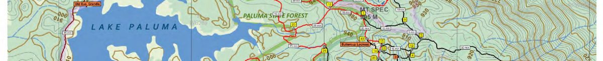
The following files are provided as an indication of the location and length of various track in the Paluma region. They are intended to aid planning of walks and orientation on the track, but are not a substitute for navigation using compass and formal topographic maps. See below for additional safety notes.
For more information on some of these tracks visit Wanderstories Paluma article
| Name | Created Date | Size |
|---|---|---|
|
|
April 25, 2018 12:45 pm | 0 KB |
|
|
April 25, 2018 1:04 pm | 0 KB |
|
|
April 25, 2018 12:55 pm | 0 KB |
|
|
April 25, 2018 12:58 pm | 0 KB |
|
|
February 17, 2020 4:51 pm | 0 KB |
|
|
January 18, 2025 1:14 pm | 2246 KB |

========================================================
Paluma/Mt Spec Walking tracks Notes: (Ver. 4 – Feb 2018)
The historical pack horse tracks, tin miners’ tracks & logging roads in the Mt Spec area provide walkers with the opportunity to explore old mining and alluvial tin workings, enjoy spectacular views of the coastal areas from rocky look-outs and discover the unique flora & fauna of the highland rainforest. The area is mostly National Park & is part of the Wet Tropics World Heritage Area, spanning from Paluma to Cooktown. The average temperatures are about 8°C lower than along the coast, making hiking in summer more enjoyable. As you are walking in a high rainfall area remember that rocks & tree roots can be very slippery. The water in the running creeks appears clear, however purification tablets are a good precaution for drinking water. Remember, the creeks around the Paluma Dam are part of the water catchment for the supply of Townsville water. If you need to relieve yourself whilst on a walk anywhere in the region please ensure you do so at least 50m from all water courses.
SAFETY
The tracks marked in blue on the map are fairly short easy walks for the general public. The others are bush tracks that require a degree of fitness and preparation. The following guidelines apply to these tracks. Don’t travel alone. Always advise someone, with reference to the map, where you are going & for how long. The area is covered by thick rainforest which makes navigation very difficult due to a lack of reference points. Please stick to the marked tracks. You should not attempt these tracks unless you or someone with you is an experienced & appropriately equipped bushwalker. Always carry a map & compass or GPS. Mobile phones cannot be relied upon for communication due very patchy coverage. Telstra appears best in the area. So a PLB (personal locator beacon) should be carried for emergency. An unplanned night out in the area can be cold & wet so carry extra clothes & protection. Stinging trees and wait-a-while vines can quickly grow up on all tracks and cause significant discomfort or injury. Either walk around these or carefully cut your way through with a pair of secateurs and wear gloves. Carry water & a first aid kit including a compression bandage for snake bites. There has been extensive mining in the area south of Mt spec & there may be forgotten mining shafts. People have disappeared in this area. Stick to the tracks!
NAVIGATION
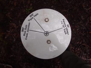
Supplementing normal bushwalking navigation methods is a network of track junction markers. The markers are a disk mounted on a star picket. At each junction the marker indicates the destination of each track & the number allocated to the junction. These junction numbers are also shown on the maps. Walkers that stick to the tracks & track their position on the map with reference to the junction markers will find it difficult to get lost.
WILDLIFE
Snakes: Most common are pythons & tree snakes which are harmless, however the dangerous Red Belly Black snakes are also present. Treat all snakes with caution & respect and do not attempt to catch them.
Native Rats: are nocturnal & are attracted by the smell of food. Keep your camping area clean & pack all food at night in your tent or suspend from a tree.
Golden Bower Birds: A number of their stick mound bowers can be seen on or near the walking tracks.
Tooth-billed Cat Birds: Their bower consists of a round area cleared of all leaf matter & then decorated with upturned silvery leaves from a particular tree.
Ticks: Most common in the dryer season. Best killed with an application of insect repellent.
Leeches: Easily removed by sprinkling them with salt or heating their rear end with a match or lighter. They also fall off with the application of insect repellent.
Wild pigs & cane toads: Unfortunately they have also found their way into the area. Pigs are very destructive to the vegetation on and around track. While attacks from pigs on people are very rare, the larger ones could be dangerous if startled.
Cassowaries, whilst rarely seen, are evident from their big piles of seed droppings sometimes found on the tracks. In time these droppings become little islands of seedlings.
FLORA
Quandong, Silky Oak, Cedar, Pimply Pine, Iron Wood, & Satin Ash are just some of the tree species found in the rain forest.
Fungi : Shape & size vary greatly, colours range from white, yellow, orange, purple & black.
Wait-a-while vine : With its rows of hooks & thorns, more common in dense thickets & along creeks should be avoided.
Gympie or Stinging tree : Mainly found on the margins of the rain forest or in regrowth under open canopy. Inflicts excruciating pain when touched. Contact with any part of this plant should be avoided. The plant is recognised by its large, heart shaped furry leaves & purple berries.
BULLOCKY TOM’S TRACK – To access the lower end, drive up Spiegelhauer Road paralleling Big Crystal Creek. Park in the Day-Use area which is about 100m on the right past the camping area. Walk another 800m along the bitumen road until an Ergon service track turns off to the right. Follow the track under the power line. Bullocky Tom’s track begins at the second power pole. Look for track markers showing where to cross the creek.
FOXLEE’S TRACK – At the coastal end, requires access through private property. Call Charlie Barbagallo on 0407 501297. Once you have his permission, drive up Volk Road and park on the verge at the end, outside the property gate. Walk through the gate & turn right following the property boundary as shown on map.
BAMBAROO TRACK – Drive up the Bruce highway until you cross Eleanor Creek about 8km north of the Frosty Mango. Turn left into the fourth driveway past the creek, street number 46395. Follow the “Comms Tower” sign onto the side track left of the gate. Leave vehicle in the mowed area inside the next gate (vehicles not to proceed past this parking area). Walk up the track to within 100m of the tower. The Bambaroo track starts here on the left. Look for track markers on trees. Please advise the property owner, Wilfred Karnoll on 47788441, if leaving a vehicle or crossing his property to do the Bambaroo track.
JOURAMA TRACK – In the Jourama National Park walk to the highest lookout & look right up the ridge for tape on trees indicating beginning of track. Refer to map.
DCK SHELTER
The shelter is erected on private property owned by Wilfred Karnoll. This roofed shelter with cooking, shower & overnight camping facilities is available for anyone to use. Please respect this property & leave it in neat & tidy condition for the next visitor. You are requested to give Wilfred a call on 07 47788441 if you intend to stay overnight.
MAPS – For a copy of walking track maps of Paluma Range NP contact Wilfred Karnoll on phone 07 4778 8441 or email wilfred.suzanne@bigpond.com.au
DISCLAIMER
Whilst all care has been taken in the production of this map, no responsibility will be taken for its inaccuracy or the safety of anyone using it.
YOUR SAFETY IS OUR CONCERN – BUT – IT IS YOUR RESPONSIBILITY!!!