The Paluma region has over 100 km of walking tracks ranging from short 20 min strolls close to the village through to major multi-day walks going north from the village all the way to Jourama Falls, or south down towards Mt Halifax and the Bluewater range.
Most of these walks follow old logging roads or mining tracks around the village and Paluma Dam. They have been established and maintained through the dedication of local resident Wilfred Karnoll and a small team of volunteers. These tracks compliment the well established National Parks tracks to Cloudy Creek and Birthday creek and are in the process of being formally incorporated into the National Parks track system. Maps of the track system are available for download here, and for those with knowledge of GPS units, a Garmin-compatible file containing the tracks and junction markers is also available.
Additional information on many of the track in the region can be found on the Wanderstories Paluma article
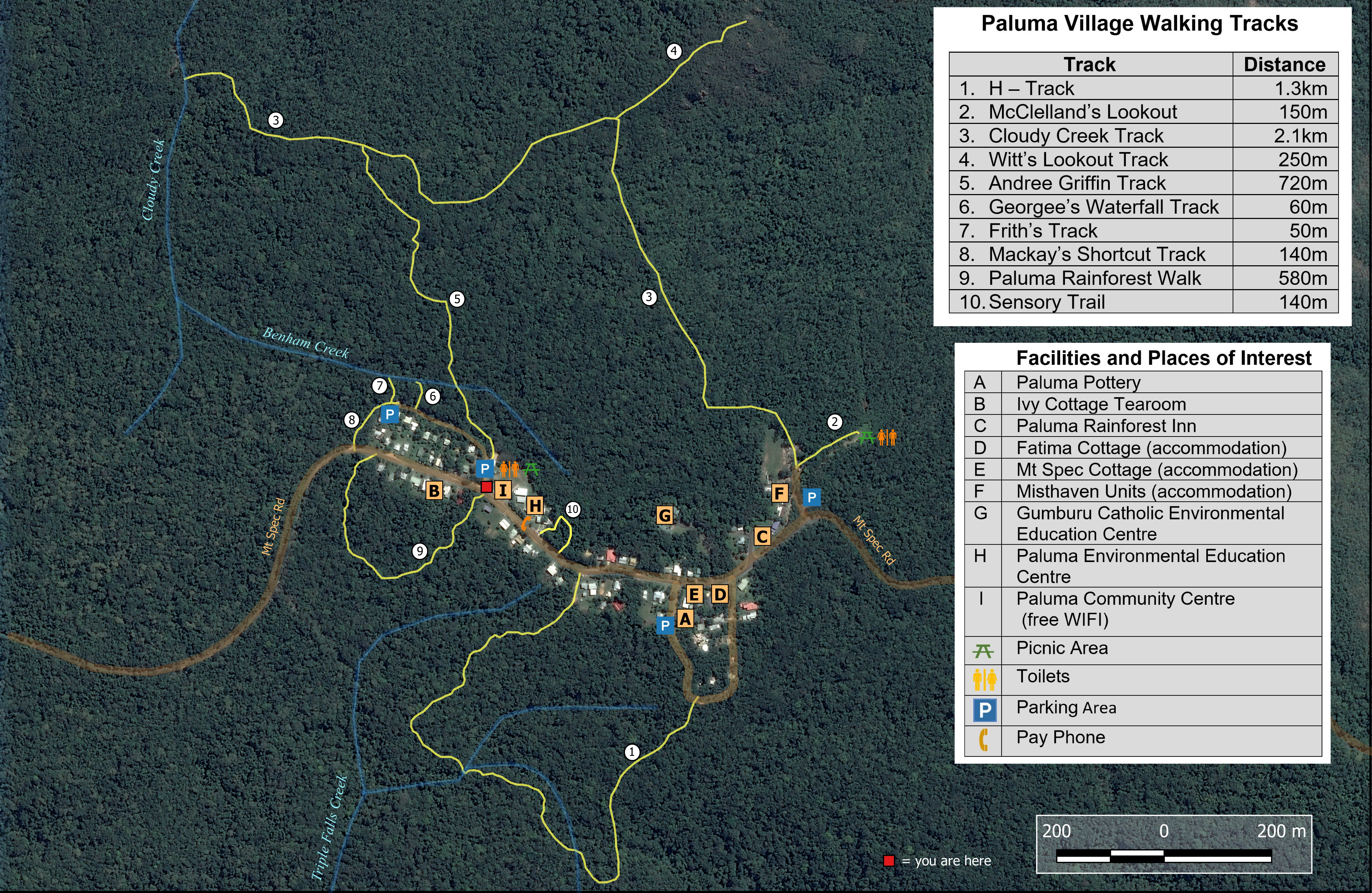
Below is a local map of the easy tracks around the village that is on display outside the kiosk beside the Community call. Most can be completed in less that 30min
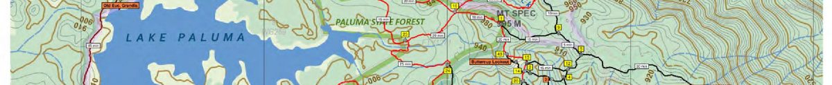
The full track system from the Bluewater track south of the Village to Jourama Falls (below) covers a huge area and includes more the 100 km of tracks, and several camping spots.
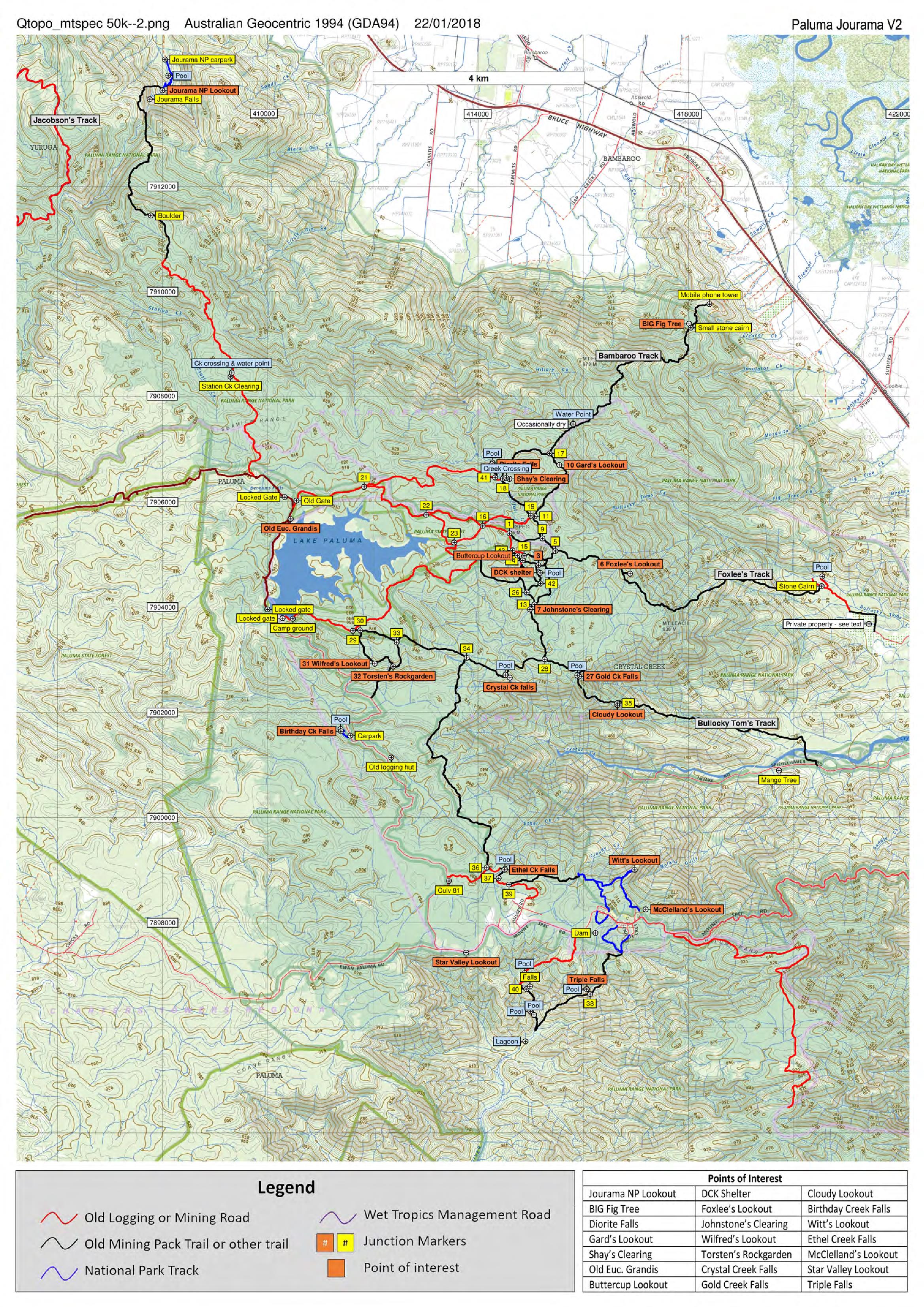
Higher resolution maps of the tracks around the dam and the village (below) are also available. Please note that the highest resolution versions of these maps are only available from the download area.
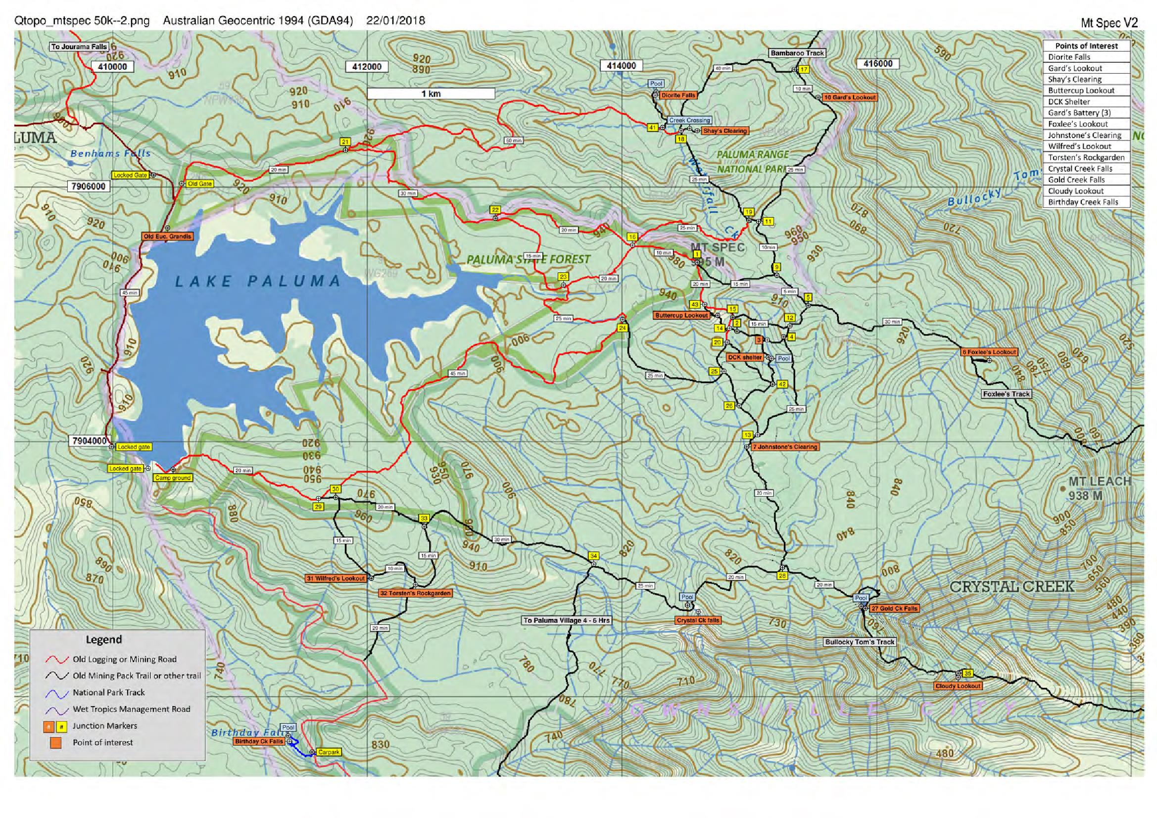
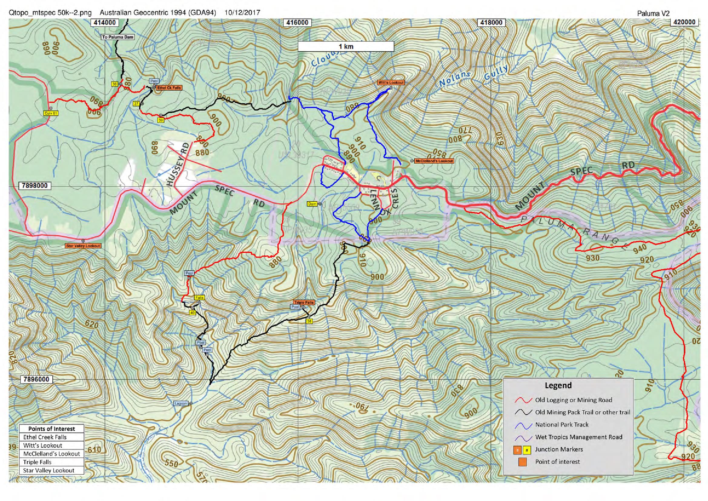
All of the tracks on these maps are maintained by a small group of volunteers. The tracks can get overgrown over time if they are not heavily used, and after storms there may be fallen trees which can obscure the track for several meters. It is always a good idea to bring a pair of secateurs to trim small branches and vines (especially wait-awhile) as you encounter them on the track. The table below shows dates when specific areas have been cleared. If a section of track has been cleared in the last 3-6 months, and there have been no major storms or rainfall events, then it is likely that the track will be pretty clear. If you happen to come across a major treefall while you are walking you can let Wilfred Karnoll know so that some maintenance can be scheduled in that area in the near future. DO NOT leave the track to walk around a fallen tree unless you can clearly see where the track continues on the other side. Fallen trees (with associated tangles of vines and wait-awhiles) can completely block your view for 5-10 meters on either side of the track and it is easy, even for track volunteers, to get disorientated once you are off the track.
| Date | Area Cleared |
|---|---|
| 14-Jan-20 | Finished clearing Smith Cr to Hussey Rd track |
| 11-Dec-19 | initial clearing of track from Smith Cr to Hussey Rd |
| 5-Dec-19 | Mt Spec car park to DCK shelter cleared |
| 2-Nov-19 | Bluewater Track now cleared up to Smith Falls |
| 17-Oct-19 | Cloudy Creek to Ethel Creek and culvert 81 on Dam Road |
| 10-Oct-19 | Finished clearing Blue Gum Circuit |
| 3-Oct-19 | Cleared old road along K traverse up to K24 |
| 12-Sep-19 | Jourama Track top half cleared; all of track now clear |
| 5-Sep-19 | Bluewater Track - from Range Road to ~1km before Taffies Rest |
| 29-Aug-19 | Blue Gum Circuit all cleared except for fallen trees needing chainsaw |
| 20-Jun-19 | Completed clearing of Black Hole track (off from Jourama track) |
| 13-Jun-19 | Finished rough clearing of Black Hole track |
| 6-Jun-19 | jourama track from falls to start of Black hole track and rough clearing of first hlaf of black hole track |
| 30-May-19 | Bottom of Jourama track up to top of falls |
| 25-Apr-19 | Bottom of Foxlees track - all of Foxlees now cleared |
| 18-Apr-19 | Mt Spec Carpark to upper part of Foxlees track |
| 11-Apr-19 | Top half of Foxlees track to end of rainforest |
| 21-Mar-19 | Junction 21 to Shay's clearing |
| 24-Jan-19 | Culvert 81 on Dam Road to Dam |
| 29-Nov-18 | Dam to Stinky Creek |
| 18-Oct-18 | Bottom of Bullocky Toms Track to the Cairn |
| 11-Oct-18 | Top of Jourama track from Rd Jcn to steep section |
| 4-Oct-18 | from Dam to Rock Garden, Crystal Ck Falls, DCK shelter, to Dam |
| 27-Sep-18 | Johnson's Clearing to near DCK and on to Dolby Ck |
| 20-Sep-18 | Cloudy Ck to Ethel Ck to culvert 81 on Dam Rd |
| 29-Aug-18 | Paluma - Bluewater track from Rd End to Fruit Salad waypoints |
| 28-Aug-18 | Paluma - Bluewater track from Rd End 1km towards mob ph waypoint |
| 24-Aug-18 | Paluma -Bluewater track from Paluma to Road End waypoint |
| 9-Aug-18 | bottom of Jourama Falls track up to top of falls |
| 2-Aug-18 | Paluma to Bluewater track up to Taffies rest |
| 26-Jul-18 | Bottom of Bambaroo Track to big Fig trees |
| 19-Jul-18 | Mt Spec car park to DCK and shortcut to Dam loop |
| 7-Jun-18 | Jourama Track from Station Creek to 1km before Road Jcn |
| 31-May-18 | Jourama Track from Benham Road to Station Creek |
| 10-May-18 | Hussey Road to Paluma Dam |
| 26-Apr-18 | Mt Spec Car Park to Johnstones Clearing and back via Buttercup Lookout |
| 19-Apr-18 | H-Track to Triple Falls to Bluegum circuit to Mt Spec Rd |
| 12-Apr-18 | Mt Spec Carpark down Bambaroo Track |
| 5-Apr-18 | Cloudy Creek to Dam Road and back via Hussey Rd |
| 15-Mar-18 | from the dam via lookout and rock garden to the shelter and return via dolby creek |
| 1-Mar-18 | from the dam via lookout and rock garden to the shelter and return via dolby creek |
| 15-Feb-18 | From Jcn 21 to Diorite Falls, Shay's Clearing and back |
| 8-Feb-18 | Mt Spec Car Park to top of Bambaroo Track ??? |
| 19-Jan-18 | Mt Spec Car Park to top third of Foxlees track |
| 11-Jan-18 | Jcn 21 to Diorite Falls and Shay's and back |
| 22-Dec-17 | Foxlees Track from Mt Spec Car Park |
| 7-Dec-17 | Dam Road to Rock Garden |
| 1-Dec-17 | From Jn 21 to Diorite Falls, Shay's Clearing and back |
| 12-Oct-17 | Culvert 81 on Dam Rd to Dam |
| 5-Oct-17 | cloudy creek, ethel creek, culvert 81, bluegum creek, triple falls, back to paluma |